The forecast was for rain and there was a downpour as I drove to the trailhead. I was prepared for rain but I would have preferred not to slog through the mud. As it turned out I was very luck. It didn’t rain at all.
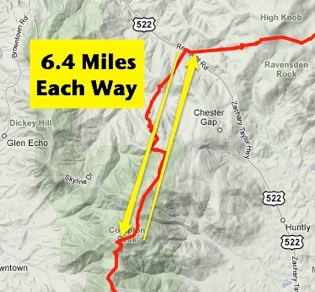
Where the Appalachian Trail crosses US 522 is where I started my hike.
 This hike was likely to be among the hardest. The trail started at 900 feet elevation and ended at 2,900 feet. However, I had to climb over a mountain before I ascended the Shenandoah Mountains to Compton Peak. My logic was that once in Shenandoah NP, since the AT rides the ridge of the range, changes in elevation should be mitigated and the hiking should be easier. We’ll see.
I can now confirm that the first leg had much more uphill than downhill! Thankfully (and by design) the return leg was easier.
Today the trail relatively crowded. Over the course of 12.8 miles I must have come across 30 people which is 15 times more than I saw on my last hike. Some of this is attributable to it being Saturday and some to being within a National Park.
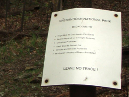
 Once I entered the Park things changed. The trail improved and widened. It seemed to have less of a grade in either direction. And of course any trace of development disappeared. Prior to becoming a National Park in 1935, 435 families living within its boundries. All were relocated. What was once farmed throughout the park has returned to its natural state.
My last thought from this hike is of photography. Since it was supposed to rain I asked to borrow my daughter Kelsey’s waterproof camera. “Is it charged?” I asked. “Sure!” she replied. After only three pictures the battery indicator started to flash red. Not a good sign! I took shots sparingly. My turn around point was Compton Peak and I wanted a picture from those heights, from that vista. When I got there I turned the camera on and within a second heard a protracted “Beeeeeeeep!” that I didn’t recognize. I checked the display and sure enough the battery was dead! Completely dead. No pictures from Compton Peak today. Good thing I start my next leg from there!
Need to talk with K about charging cameras & carrying a spare battery!
 VA-Section 6 (click here for interactive AT map)