Categories
Bike Mountain Travel

The AT: My Hike-Bike Loop

Along the Appalachian Trail, a stretch from Compton Gap to Hogback.

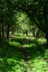
Finally I’m hiking wholly within Shenandoah National Park. Better still, the Appalachian Trail is roughly paralleling Skyline Drive which runs along the crest of the 105 mile long national park. As you can see above, it’s beautiful country seen on a spectacular day.

To this point I’ve had to hike the AT and then retrace my steps to get back to my car. This essentially had me walking each stretch of the AT twice, once in each direction. If covering the length of the park is my goal then this was a pretty inefficient way to go about it. With the Trail loosely following the road I now had an option. I could hike one way and bike the other.
linkedinmailby feather
Categories
Hike Mountain Travel

The AT: Entering Shenandoah

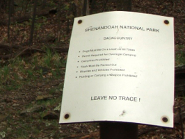
Leave No Trace
As with many borders, were it not for the signs you wouldn’t know there was a border. Along the AT into the Shenandoah National Park I saw this sign ... I was glad to have arrived!

The forecast was for rain and there was a downpour as I drove to the trailhead. I was prepared for rain but I would have preferred not to slog through the mud. As it turned out I was very luck. It didn’t rain at all.

Where the Appalachian Trail crosses US 522 is where I started my hike.

linkedinmailby feather
Categories
Hike Mountain Travel

The AT: Appalachian Trail

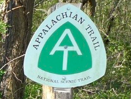
AT Sign
There are few of these signs along the way but they’re located at strategic points. Here, next to I-66, was the start of the segment I hiked which is referenced as VA-Secton 5.

The trail is 2178 miles long and runs from Maine to Georgia. It’s world renown and it runs through the Shenandoah Mountains which are practically in my backyard. I like hiking  so it’s a natural stomping ground for me. My past walks along it were purely by chance as parts of different hikes. Today my goal was the AT.

linkedinmailby feather
Categories
Hike Mountain Travel

Old “Cloudy” Rag

Cloudy Old Rag
In winter, when the rock scramble is less travelled, moss has accumulated and the rock is wet, it’s really slippery up there. Today’s hike was an exercise in caution ... but there was still lots of sliding going on.

Today I climbed Old Rag again. It was supposed to be sunny. It was not!

Took my hiking GPS and here are a few insights:

  • Initial Elevation: 600 ft
  • First Peak Elevation: 2800 ft
  • Second Peak Elevation: 3300 ft
  • Total Hiking Distance 7.8 miles
  • Temperature Range: 36 – 43 degrees

Oh, and look at what I found in the middle of nowhere …

linkedinmailby feather
Categories
Hike Mountain Travel

The Glorious Old Rag Scramble, Again

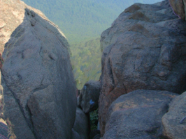
Bolders on top of Old Rag
Two peaks between which lie a wonderful series of rock scrambles. The fun doesn’t get old no matter how often I climb Old Rag Mountain in Shenandoah National Park.

There are other places to hike but I keep being drawn back to Old Rag. If I leave at 7:30 AM then I can be back by 3:00 PM after having climbed a mountain, scrambled over rocky terrain, and taken-in stunning views. Total distance is 7.5 miles. Total elevation is 3,200 feet.

Climbing the front is a vigorous effort but your reward is the first peak where a rocky plateau greets you. The views are spectacular and it’s a good place to catch your breath. Soon again you lose your breath as you climb to the second peak across, between and under lots of rock. The descent is 4.5 miles of the total hike and three of those miles are a long fire road, uninteresting but for the three rivers you cross. At that point in the hike though, boring is good.

This hike is recommended, recommended, recommended.

linkedinmailby feather
Categories
Hike Mountain Travel

This Rock Scramble Doesn’t Get Old

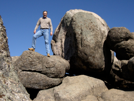
Travis atop Old Rag
The climb takes 2 hours. The gradual decent takes 90 minutes. The base of Old Rag is 1:40 from my home. If leave by 7:30 AM then I’m home by 3:00 PM. Can you tell I’ve hiked this mountain a few times?

I did it again.

I hiked Old Rag Mountain.

Why?

Simple. The top third of the climb is a fun rock scramble that never seems to get old. When I saw the forecast for today I had no doubt what I’d do. I was going to hike to this rock playground-for-adults named Old Rag Mountain.

Curious about my favorite 8.8 mile circuit hike? Learn more here.

linkedinmailby feather
Categories
Mountain Ocean River Road Summary Travel

The World’s Longest National Road – Driving the TCH

TCH Walking Tours
Every Yellow Icon Represents a Night's Stay in Canada

Since I was going to drive the length of the Trans-Canada Highway (TCH), from St. John’s, Newfoundland to Victoria, British Columbia, I was going to need regular exercise so as to stay fit and an engaging project to keep my mind occupied and interested. If I could do both and at the same time learn a lot about Canada then all the better.

The answer of what to do came from a book entitled “Canada: Coast to Coast” which not only details thousands of points of interest along Canada’s major highways, but also includes full walking tours for 14 of Canada’s largest cities. Twelve of these 14 were along my chosen path so I resolved to walk all twelve tours.

This site is not about my walking tours.
This site is about something I did during each tour.
At every tour stop I recorded a brief video from my wife and daughters.

This page has the videos I made across my three week journey down the TCH (12 Apr 07 – 2 May 07).

linkedinmailby feather